Saturday 31 August 2024

Watercolour in Daler-Rowney Sketchbook

This is a post that combines two of my more recent subjects for posts in one. You have to admire that kind of economy, don’t you? My last post was about having made my first pictures outside of the UK and Europe. Well, continuing in the same vein last week I painted a scene from the New York subway – the 1 Train (Line 1) in uptown Manhattan above ground. Here it is if you don’t believe me.


Please feel free to hold your own opinion about the quality of the painting or otherwise. Personally, I’m not unhappy with the way that it turned out considering how despondent I was feeling after the first session. But that isn’t really the point of the post. I made the painting in my Daler-Rowney special edition A4 sketchbook. The pages are 150 gsm and I have to say I am amazed at how well it took the watercolour. I’m talking about the way that it stood up to the watercolour. There’s no discernable cockling or buckling. If anything it did at least as well if not even better than my Winsor and Newton book and that’s 170 gsm. Big tick for D and R from me.

Friday 23 August 2024

I am now Transatlantic

I am delighted to say that I can now call myself a transatlantic urban sketcher. On 6th August I flew to Dublin, then on 8th August I flew from Dublin to New York. I flew back to Dublin on the 13th and then back home on the fifteenth. So here’s the sketches I made in Dublin and New York.


Monday 5 August 2024

A4 Hardbound Sketchbooks again

On May 6th  I posted about different hardback A4 sketchbooks that I’ve used. I’ve had good things to say about Mont Marte, Seawhite and Winsor and Newton, with a marginal preference for the Winsor and Newton. 

Top left - Daler Rowney Ebony - Top right - Winsor and Newton - Bottom left - Mont Marte

 - Bottom right - Seawhite of Brighton

I enjoyed using all of them but just preferred Winsor and Newton. The 170gsm paper of this book takes fineliner better than the other two. Using a 0.05mm fineliner produced noticeably finer lines in this sketchbook than in the other two. This makes the marks just a little bit sharper. I wouldn’t say that there’s a huge amount in it, but it’s there. Also, in the first sketch in the book there isn’t even a hint of showthrough – but then this was also true of some of the pages in both of the others, so I’ll keep an eye on how consistent this is. To my eye the same watercolour set is brighter and more vibrant on this paper, and there’s noticeably less buckling. You could comfortably sketch on the other side of the paper, and I shouldn’t be surprised if you could paint on it as well. One feature I’ve noticed is that the pages are perforated so you have the option of removing them more easily from the book, should you choose to do so.

Okay. Now, or my 60th birthday back in mid-June I was given lots of lovely drawing stuff, including this – A Daler Rowney Ebony Special Edition Sketchbook. I believe that the special thing about this is the Union flag cover. Nothing against that either. I’ve been a while getting on to using it because I preferred to use a landscape format book for my bridges and tunnels challenge. But when I made my sketch of the Woolwich Ferry on Saturday that finished off my second Mont Marte sketchbook, and so it made sense to do the Thames Barrier sketch in the Daler Rowney.


Okay, so I’ve only made this one drawing in it but my first impressions are very positive. The paper is smoother than the Seawhite book, and much smoother than the Mont Marte, and comparable to the Winsor and Newton. It’s a pleasurable surface to draw on, although I do know some sketchers prefer just a little more tooth.

The weight of the paper is 150 gsm, the same as the Mont Marte and slightly heavier than the Seawhite. The Winsor and Newton is 170gsm. I haven’t applied watercolour to the new book yet, so I don’t know how well the Daler-Rowney copes. But I can say that as a general sketchbook for drawing, this is a nice product I’m happy to use, albeit I still have a slight preference for the Winsor and Newton.

Using today’s prices on Amazon the Seawhite is £8.95, the Winsor and Newton £10.64, the Daler Rowney £12.29. I can’t find the Mont Marte on Amazon. But in all honesty you can find great deals on all of these if you’re prepared to shop around a bit which means that you don’t need to let the price dictate which you go for.

Sunday 4 August 2024

That Challenge is complete

Time is getting on. In a couple of days I’m off on the great summer Sketchpedition of 2024. This has give me some oomph to finish off the tunnels. Here they are:-

Woolwich Foot Tunnel

You know, when you hear the word Woolwich, you might not have anything specific come to your mind, especially if you’re not from London or the South East. But if the name does mean anything to you, there’s a number of things that might be, depending on your age. You might be interested in the fact that the very first McDonalds in the UK opened in Woolwich – and it’s still there. If you’re of an older generation you maybe think of the Woolwich Ferry. Well, we’ll see about ferries in the fulness of time. Most likely, if you thought anything you thought Barrier, since Woolwich is home to the Woolwich Flood Barrier across the Thames.

Well, the foot tunnel has nothing to do with this.

The Thames Flood Barrier at Woolwich does have a tunnel linking the gates and the banks of the river, but it’s certainly not open to you and to me, being a service tunnel and therefore not part of my remit.

No, we’re here in Woolwich to look at the Woolwich foot tunnel. Like the slightly earlier Greenwich Foot Tunnel, the Woolwich tunnel was the result largely of energetic lobbying by working class politician Will Crooks. The Woolwich tunnel is longer than the Greenwich Tunnel, and it has about 1000 users a day on average compared with the 4000 on average who use the Greenwich Tunnel each day.  Like Greenwich the tunnel walls are lined with white glazed tiles, although there’s none of the  temporary war damage repairs which are still so glaringly obvious in the former. The entrances to the tunnel are similar to Greenwich, but the lack of a dome means that I prefer the Greenwich entrances.

I only ever used the tunnel once, forty years ago so I can’t say if this is in anyway unusual but on both crossings I was the only person in the tunnel.

In 2010 the tunnel was closed when structural weaknesses were discovered. At its deepest point the roof of the tunnel is less than 10 feet below the riverbed. It reopened late in 2011.

One thing I can’t tell you is whether you can cycle in it officially. I’ve read several websites saying you can at off peak times, but the official Woolwich Tunnel website states categorically that cyclists are expected to dismount at all times. So, I guess you pays yer money and takes yer chance on that one.

Elizabeth Line Tunnel – Custom House to Woolwich

Right then. When I was a kid, life was a lot simpler. You had London Underground trains, the Tube as we called even the above ground sections, and you had British Railways. Yes, it was complicated a little by the Waterloo and City Line which looked like a tube line, appeared on the Tube map, but was actually a British Rail line, but since this was only one tiny line between two stations we could forget about it for most of the time. Nowadays we have the London Underground, the London Overground, the Docklands Light Railway and the Elizabeth Line, all under the same Transport for London branding, yet all separate entities. The Underground spends more of its time overground than underground while the Overground goes underground in places. It can all be quite confusing. Ironically the Waterloo and City Line is now part of the London Underground network, so let’s at least be grateful for small mercies.

The Underground Lines of London built in the fifty years before the First World War, still form the core of the network in Central London but were never designed to cope with a population of nearly 9 million people. Even with the various extensions to the network since and with the additions of the Victoria and Jubilee lines, even before 2000 it was obvious that the network was struggling to cope with the volume of passengers. The Crossrail Project to alleviate the problem was first discussed in 2001. In 2008 the route was settled and Parliamentary Approval secured. Work began on what would become The Elizabeth Line in 2009.

Boring of the tunnels took 7 years, which is hardly surprising considering how congested Central London is. Crossrail was the largest engineering project in Europe at the time. The original opening of the line was scheduled for 2018, but this was delayed and then delayed again due to the Covid 19 pandemic. The line opened in 2022.

There are many differences between the Elizabeth Line and the lines of the London Underground. The tunnels have a wider diameter, and the trains are longer, bigger and carry many more passengers. At the time of writing in 2024 it is such a success that it’s estimated that one in seven of all rail journeys in the UK are taken on the Elizabeth Line. The line passes through Central London but it’s much longer than any Underground Line, stretching from Reading in the West to Shenfield in the East, and there are plans and proposals to extend it as far afield as Southend airport. Its 41 stations compare with 60 on the District Line for example, and the greater distances between stops allow the trains to travel at a higher average speed than the Underground.

So, the Elizabeth Line’s cross river tunnel links Custom House, already a DLR station, with Woolwich, on a spur which ends at the next station at Abbey Wood. In the early days of the Crossrail proposal there was not going to be a station at Woolwich. However involvement with Greenwich Borough Council and the Berkely Homes Development Group with he cost of a new Woolwich station meant that Woolwich was included by the time that Parliamentary Approval was gained.

DLR tunnel – Woolwich Arsenal to King George

The Docklands Light Railway tunnel between King George V station and Woolwich Arsenal Tunnel is the furthest upstream crossing of the Thames in Greater London, and the end of our subterranean journey back and forward across the Thames. The next crossing is the Dartford Tunnel between Kent and Essex more than ten miles away.

Woolwich Arsenal station is shared between the DLR and national rail. The DLR platforms are underground and the end of this section of the DLR. Trains arrive at and depart from either side of an island platform. The station is the end of the line extending out to London City Airport which was built between 2005 and 2009, and opened in the latter year.

The DLR tunnel under the Thames to King George V is not without interest, since it curves around so much that trains departing Woolwich Arsenal head eastwards, while the tunnel curves westwards under the river.

As for King George V station in North Woolwich itself, well I don’t have a great deal to say about it. The station platforms are a distance from the tunnel and are above ground. The station was opened in 2005 even though it would be four years before the tunnel to Woolwich was completed and Woolwich DLR platforms were open. Every time I’ve visited the platforms have always struck me as a bit bleak and the exterior of the station is pretty uninspiring.

-----------------------------------------------------------------

I wasn’t done yet. Not quite. You see, I’ve missed out something obvious. The first tunnel beneath the Thames opened in 1840. The first London Bridge was built in about 50AD. In the 1990s remains of a Bronze Age structure from about 1500BC were found in the Vauxhall area, and this may have been a bridge to an island, although this is still a hypothesis rather than a proven fact. Yet for all this we can be pretty certain that the first people to cross the Thames did so in boats.

From the Saxon reoccupation of the walled Roman city of Londinium a settlement on the south side of the river around the southern end of the bridge called Southwark grew. A thriving and powerful community of Watermen took advantage of the increased traffic between London and Southwark. The boats they used were called wherries. In medieval times Southwark was not subject to the restrictions of the City and it developed a reputation as a place where people could enjoy the kinds of amusement and entertainment not permitted in the city– it was no accident that the Globe and Rose theatres of Shakespeare’s time were both in Southwark. The wherries had become water taxis, and the watermen vigorously opposed the building of any new bridges in London until Putney Bridge in 1729.

Various ferries have run across the Thames throughout the centuries. The proliferation of Bridges and tunnels in the central London area in the last two hundred years has drastically reduced the demand for ferries, but there are still a couple of scheduled ferry services across the Thames in the Greater London area, and so let’s add these to the challenge. The completist in me would never forgive me if I didn’t.

I have to be honest, I found it difficult to keep interest in the tunnels. Most of them were train station platforms and although none of them are identical, they’re pretty similar and it’s really a matter of straight lines and perspective. I don’t plan to do another one for a while, although I’m not rulig out the New York Subway. The ferries perked up my interest a bit, and I did the last two tunnels and all four ferries across just a couple of days. Here they are.

Hampton Ferry

The Hampton Ferry has a very good claim to being the oldest ferry service on the Thames in London. Mind you, it’s only just in Greater London. It runs from Hampton to Molesey. I’ve never used it myself so what I know about it is derived from what I’ve found online, and if there are mistakes, then I apologise.

It runs from March to October and judging by the photographs it only carries a small number of passengers. But you have to admire the fact that it has been ging since 1514.

Hammerton’s Ferry

Hammerton’s Ferry has not been running since the 16th century. Again, like the Hampton Ferry I have never yet used Hammerton’s Ferry, so I apologise for any errors in what I have to say.

Right. Up until the 20th century the land on either side of the Thames a this point of the river between Teddington and Richmond was privately owned. During the 1900s Marble Hill House and Park on the north side were purchased for public use, and the footpath on the southern side near Ham House became a public right of way. A local resident called Walter Hammerton began hiring out boats from a boathouse opposite Marble Hill House, and by 1909 he was operating a ferry service carrying up to 12 passengers, each paying one penny.

Despite legal challenges and appeals to Hammerton’s right to run the ferry service which finally ended when he House of Lords upheld Hammerton’s side, he continued to run the service for 38 years. I don’t know if this is true but sincerely hope it is that world famous musician Phil Collins is Walter Hammerton’s grandson. I know Phil Collins is a West London boy, so you never know.

The ferry is still in private ownership. Hammerton’s original ferryboat is on display at the Museum of London Docklands. The current ferry still operates on the original route from near Marble Hill House to near Ham House. The current ferryboat was manufactured in 1997 and is called Peace of Mind. It operates on weekends all the year round and also on weekdays from February until October.

Transport For London River Bus

Yes, include the Transport for London River Bus services. Strictly speaking most of these routes aren’t counted as ferries, but what the hell, it’s my game and we’re playing by my rules or I’m taking my ball and going home.

London River Services Ltd. are part of Transport for London. They don’t actually run the three London river bus services, but manage them by licensing the services of operators. This had its roots in an initiative by Labour’s Transport Secretary in the 1997 Government, John Prescott. Prescott was also the Deputy Prime Minister so he had a lot of clout within the Government and could get things done. This resulted in the creation of London River Services. It directly manages 8 piers, and has tied in branding with the rest of TfL.

Route RB1 goes from Battersea Power Station Pier to Barking Riverside Pier , which is also the destination of RB2 which starts at Putney Bridge. There is currently no RB3. RB4, which I used twice in 2016, is the shortest route of all and is essentially a ferry between Canary Wharf and the Doubletree dock by the Hilton Hotel. There is no RB5, and RB6 operates at peak times on weekdays between Putney and Canary Wharf.

Woolwich Ferry

So, the ferry between Canary Wharf and the Doubletree dock is licensed by London River Services Ltd. and officially designated River Bus Route RB4. The Woolwich Ferry is also licensed by London River Services Ltd. and officially designated the Woolwich Ferry. Personally I think that this is a bowing to the inevitable. The Woolwich Ferry has been the Woolwich Ferry since 1889, and even if it was officially called route RB whatever the hell you like, people would still call it the Woolwich Ferry.

The first mention of a ferry on this part of a river is in a paper dated to 1308. In 1320 the ferry was sold for 100 silver marks. No, I don’t have the first idea how much that is in 2024 money, but you can bet your life it was a pretty penny back then.

The Royal Arsenal was established in Woolwich in the 1670’s which only increased cross river traffic at this point of the Thames. So much so that the Army created its own ferry service in 1810. Various commercial ferries operated in the mid 19th century, but bowing to public pressure the Metropolitan Board of Works agreed to provide the infrastructure needed for a free, public steam ferry service and this opened in 1889.

Like may of the bridges and tunnels across the Thames, at different times there’s been concern over the capacity of the Woolwich Ferry Service. Demand continues to be high especially with modern HGVs unable to use the Rotherhithe and Blackwall Tunnels.

The Ferry service has seen a number of owners in its time. Just two days before it opened for business in 1889 the Metropolitan Board of Works was replaced by the London County Council. This in turn was replaced by the Greater London Council (GLC) in 1965. The GLC was abolished in 1986 when responsibility passed to the Ministry of Transport. The Secretary of State passed operating responsibilities to the London Borough of Greenwich, then TfL took over asset ownership and responsibility for operating the service. Several operators have been licensed by TfL over the years, but the current operator is London River Services Ltd. themselves. There you go.

Finally, this morning for the sheer hell of it I also sketched the Thames flood Barrier at Woolwich – you can see it partly in the sketch of the Woolwich Ferry. 


Thursday 1 August 2024

More tunnels

 The Thames crossing challenge continues. Here's the latest sketches.

Rotherhithe Tunnel

Rotherhithe is the furthest upstream of a well known trio of road tunnels beneath the Thames; this one, the slightly earlier Blackwall Tunnel, and the Dartford Tunnel which is outside of Greater London and so strictly speaking none of our concern.

The tunnel was built to link the Limehouse and West India Docks to the north with the Surrey Commercial Docks to the South. The construction largely copied that of the Blackwall Tunnel, although the diameter was wider and there were claims that it was the largest subaqueous tunnel in the world when it was built. Speaking of its construction, one of the great claims to fame of the Rotherhithe Tunnel was that the safety precautions for the men building it were so comprehensive that not a single person was fatally injured during its construction, which was a rare occurrence indeed for tunnels built in the late 19th and early 20th century.

The Rotherhithe Tunnel is unusual inasmuch as it carries motor vehicles, cyclists and pedestrians all within a single bore. The portals at either end of the tunnel are now grade II listed. The tunnel has fairly sharp bends and the carriageways are narrow, and this means that there is a ban on vehicles more than 2 metres high or 2 metres wide. There is a speed limit of 20mph in operation throughout the tunnel. Originally the walls of the tunnel were faced with glazed tiles, with a band of brown tiles marking the boundary between northern and southern halves of the tunnel. There were problems especially with the tiles on the southern half and the tiles were removed in 2011. It’s a shame, since for my money this has done nothing for the tunnel’s aesthetic appeal.

Maybe this has something to do with the tunnel’s virtual abandonment by pedestrians. This has dwindled to the point where the current estimates suggest that the average number of pedestrians using the tunnel each day is 20. Personally I think it probably has more to do with the really unpleasant fumes inhaled by those who brave it. By 1997 over 34,000 vehicles were using the tunnel each day, which is far more than it was ever designed for. Restrictions since have kept that figure from rising, as this is seen as pretty much the tunnel’s full capacity.

I will be honest. Although I have driven through the Rotherhithe Tunnel I have never been tempted to cycle through it or heaven forbid, walk through it. Generally it is felt to be really unpleasant, and some have even suggested unhealthy. Just google ‘walking through Rotherhithe tunnel’ and you’ll find plenty of first hand accounts that say as much.

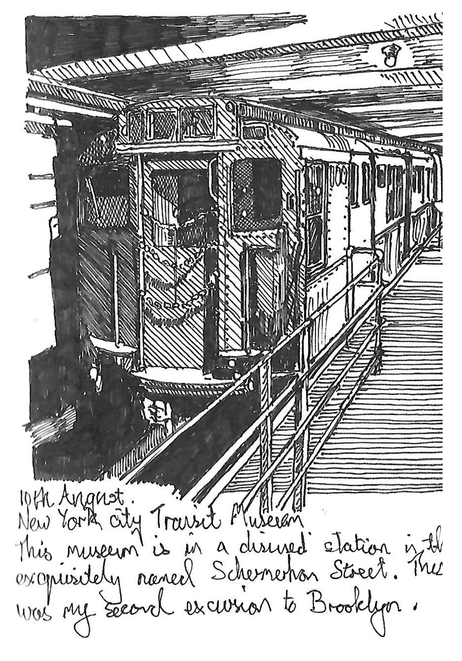
Jubilee Line – Canary Wharf to Canada Water

Yes, we’re back to London Underground’s Jubilee Line. Here’s a funny thing. The Jubilee Line had its origin in a new London Underground Line which was going to be called the Fleet Line, since it was partly going to follow the course of one of London’s ‘lost’ rivers, the Fleet. Planning began in 1965, and while the planned route changed over the years, so did the name. It was renamed the Jubilee Line after Queen Elizabeth II’s Silver Jubilee in 1977. This is why it’s coloured light grey on the tube map – it is meant to represent silver. This being the 70s, the Line itself didn’t open until 2 years after the Jubilee, in 1979.

It was always intended that the Jubilee Line would be extended, but several plans were considered, then changed, then rejected, before work finally began on the extension south of the river and into London’s Docklands redevelopment. New platforms were built at Westminster, Waterloo, London Bridge, West Ham and Stratford, and 6 brand new stations were built including Canada Water and Canary Wharf.

The new Jubilee Line Extension stations have been rightly praised for the imagination that their architects have shown in their designs. Even as I write a quarter of a century after their opening they seem fresh, and new and in the case of Canary Wharf in particular, a vision of the future. Not that building the line between the two stations was by any means an easy thing to do. It was complicated by the presence of the foundations of some of the tallest office buildings in the UK  in Canary Wharf and a 19th century railway tunnel. Despite this the line opened on schedule in 1999, which shows you the contrast between Britain in the 1970s and the 1990s.

Cards on the table – I like the Jubilee Line. I’ve used both Canada Water and Canary Wharf stations and both have proven to be a very pleasant experience.

Okay, confession time. I really liked the photograph I found and used for the picture, and it wasn't until I was about half finished that I suddenly asked myself - where are the doors? For the Jubilee Line has glass walls with automatic doors between the platforms and the trains. The answer is that it isn't the Jubilee Line platforms, it's the Overground.  Canada Water serves both Underground and Overground. The station at the other end of the Jubilee Line tunnel under the Thames here, Canary Wharf doesn't serve the Overground, but does serve the DLR and is very close to the Elizabeth Lne station of the same name. There you go. 

Docklands Light Railway Tunnel – Island Gardens to Cutty Sark

Coming back to the Jubilee Line, the Docklands Light Railway (DLR) had its origins in proposals for the Jubilee Line extension. The Thatcher Government of the 80s rejected the idea as too expensive, but did want to pursue a cheaper, light railway public transport system. The original DLR ran from northern termini at Tower Gateway and Stratford to Island Gardens in the Isle of Dogs, just across the river from Greenwich. All the stations were above ground.

The growth of Docklands saw the DLR extended during the mid 90s, to connect with the Underground at Bank, and out into East London. It was Lewisham Borough Council that first mooted extending the system via a tunnel beneath the Thames between Island Gardens and Greenwich, extending out to connect with Lewisham’s existing British Rail Station. They commissioned a feasibility study which was enthusiastically received by Parliament. Consent was given and work began in 1996.

One consequence was that it was necessary to resite Island Gardens station. The new station is a shallow subsurface one, after which the line enters the tunnel under the Thames. The next station is Cutty Sark, after which the tunnel ends at Greenwich station. The extension opened in 1999.

I am well aware that not everyone loves or even likes public transport. I will admit that after I moved to Port Talbot I developed a dislike for the local buses and trains – mostly to do with their irregularity and scarcity. I am glad to say that my opinion has changed since receiving my free bus pass. Returning to the point, I do think that for anyone with even a sneaking regard for public transport, a ride on the DLR is well worth your time. If you can, you should sit in the front of the driverless train and watch the spectacular vault of Canary Wharf station approach you. 

Greenwich Foot tunnel

Many years ago in my dim and distant past I studied English Literature at Goldsmith’s College in New Cross. For the majority of the three years of the course I lived in a student hall on the edge of Blackheath. One particular pleasure was walking across the heath, and then down into Greenwich.

In Greenwich, by the riverside, not at all far from the Cutty Sark, is a rather curious looking circular, domed red brick building. This is the Greenwich entrance to the Greenwich Foot Tunnel and prior to the opening of the DLR Lewisham Extension it was by far the easiest way to cross the river between Greenwich and the Isle of Dogs.

I didn’t have much occasion to cross to the Isle of Dogs during my three years in Lewisham, but out of curiosity I did use it on a few occasions. It was over 80 years old, having first opened in 1902 and to be honest it felt like it. The original lifts were still in use and would continue until being replaced in the 1990s. The tunnel to my eyes seemed fairly narrow. Having grown up with the London Underground it only seemed natural that the tunnel should be lined with white tiles, but back then I recall there was a bit of a damp problem, and some of the tiles looked unnecessarily mouldy. Someway into the tunnel the tiles cease and you get what look like cream coloured exposed tunnel rings. These are actually repairs to the tunnel made following the explosion of a bomb nearby in 1940. If the rest of the tunnel felt narrow, this section felt almost claustrophobic. These repairs were only temporary, even though, over 80 years later they’re still there!

Well, let’s be a little kinder to the poor old Greenwich Foot Tunnel. I was impressed to read that once it really got into top gear, the tunnel progressed at a remarkable 10 feet per day. It is open all day every day and its still used by a average of four thousand people a day. I read that upgrade work was undertaken in the second decade of the present century to ameliorate some of the problems with dampness. Signs in the tunnel make it clear that you’re not allowed to ride your bike in the tunnel, but I did wheel my bike through it when I was on my way from Lewisham to relatives in Essex, and it was significantly quicker than cycling to Tower Bridge and crossing the river. . . and significantly healthier than riding through the Rotherhithe Tunnel.

Jubilee Line – North Greenwich to Canary Wharf

Yes, the Jubilee Line is the gift that keeps on giving. For once you’ve crossed from Canada Water to Canary Wharf, then you get to cross right back to North Greenwich.

One of the driving forces behind the Jubilee Line extension was facilitating access to what was at the time called The Millenium Dome in Greenwich. In 1851 The Great Exhibition was held in Hyde Park in the building which came to be known as The Crystal Palace. The purpose of the Exhibition was to showcase Britain's and other countries’ culture and commerce. It’s been credited as the brainchild of Prince Albert and whether that’s strictly true or not he was a primary mover and shaker behind it. The building itself was bought, dismantled and reerected at Sydenham Heights, where it stood until destroyed by fire in 1936, after being used for a variety of purposes.

In 1951, Britain staged the Festival of Britain. The original inspiration was the Centenary of the Great Exhibition. The Great Exhibition however was the first ever World’s Fair, while the Festival itself was a purely British affair, focused on Britain and its achievements. Festival events took place throughout the year and throughout the country. The focal point for the celebrations was the temporary complex built on the South Bank from early May until the end of September. At the end of the year almost the whole complex was demolished, although the Royal Festival Hall remained, and still does.

So, the Great Exhibition and the Festival of Britain served as inspiration to the John Major Conservative government of the mid 90s for a public exhibition to celebrate the Millennium. The Labour Government elected in 1997 took the plans and greatly expanded them. The exhibition was always going to be held in the Millennium Dome, built at North Greenwich. The Dome, which is supported by 12 100m tall towers, is still one of the largest in the world. The twelve towers spaced around the circumference of the dome are inspired by a clock face, a nod to Greenwich being the home of the Greenwich meridian. Curiously the Dome's footprint is almost exactly the same as that of the original Crystal Palace.

You can use statistics to argue that the Millennium Experience in the Dome was either a huge success or a huge flop. In the 12 months it was open it attracted just over 6 million visitors, making it by far the most popular tourist attraction in the UK, by a factor of 3. On the other hand the Festival of Britain attracted 10 million visitors over a shorter time period. In the years following the Dome was sold, and has been renamed the O2 Area, where its huge indoor space has been used for multiple events, most notably as a sports arena and concert venue. I visited it myself to see the Treasures of Tutankhamen Exhibition in 2008.

So, in the same way that the Jubilee Line Station at Canary Wharf has tunnels crossing under the Thames on both sides of the line, so does North Greenwich. However, in between we have . . .

Blackwall Tunnel

Yes, the Blackwall Tunnel. The Blackwall Tunnel is a road tunnel that links Blackwall in Tower Hamlets with North Greenwich.

By the 1880s, two fifths of London’s population lived East of London Bridge. Yet London Bridge remained their nearest river crossing. The same growth of London’s docks that made new crossings more necessary also meant that more bridges East of Tower Bridge were going to be too much of a restriction to shipping.

An Act of Parliament for the building of a Blackwall Tunnel was passed in 1997. This tunnel was the brainchild of Sir Joseph Bazalgette and would have composed of three bores, two for vehicles and one for pedestrians. However the Metropolitan Board of works, whose responsibility it would have been was abolished in 1889 when the London County Council was established. This ended Bazalgette’s involvement.

It didn’t end the tunnel as a concept, and the LCC’s chief engineer Sir Alexander Binnie designed a single bore tunnel that would be built using the Greathead tunnelling shield and compressed air method and it opened in 1897. By comparison with the slightly later Rotherhithe Tunnel, 7 men lost their lives during the construction. The original bore, the western bore, is now only used for northbound traffic. It has some sharp bends and there is a maximum height limit for vehicles of four metres.

By the 1930s it had become generally accepted that the tunnel was inadequate for the volume of traffic using it. It was not until 1938 that the required Act of Parliament for a new tunnel to be constructed was obtained by the LCC. As you might have deduced, work on the new tunnel was considerably delayed due to the outbreak of World War II and the subsequent period of post war austerity. It was not until 1958 that work commenced. That was only on the new approach roads. Work on the tunnel itself began in 1960 although the tunnel itself was not opened until 1967. It is wider than the original bore, and takes a shorter, more direct route under the river.

The northbound entrance to the original tunnel still stands and certainly in terms of appearance it puts me just a little in mind of what Tower Bridge might have looked like had it been built in red brick as Horace Jones originally intended. Out of interest, horse drawn traffic is banned in the tunnel, but the ban didn’t come into effect until 1947.

Being the easternmost road crossing of the river in Greater London the Blackwall tunnel is one of the most important crossings of the whole river, and has seen criticism for the amount of congestion around it for decades. There have been proposals over the years to build a third bore. Finally  in 2018 the Government agreed to the proposal of a new tunnel between Silvertown and Greenwich. The opening of the new Silvertown Tunnel has been proposed for 2025. Watch this space. Charges will be imposed for using the Blackwall Tunnel for the first time when the new Silvertown Tunnel opens.

Jubilee Line – Canning Town to North Greenwich

Yes, folks, the mighty Jubilee Line rolls on from North Greenwich, crossing under the river again before it reaches Canning Town. Well, this is the last time that it does so. Canning Town is an interchange station with the DLR.

I have to say that at first glance the Northern entrance, which is the main entrance to the station, looks tired and uninspiring. Concrete panels rarely look inspiring, and once they’ve had a few years to get dirty, as these have, they look even less appealing. Even the parts which make less conspicuous use of concrete and more use of glass and metal are flat and rectangular and speak more of dull bus station than imaginative tube station design. One thing it does have which is worth writing about is a huge memorial to the Thames Ironworks. Remarkably this claims to have been made from inscribed concrete panels attached to iron hewn from the hull of HMS Warrior. I’ve no doubt that it did originally come from HMS Warrior, but I just wish it explained how Warrior is still in existence, proudly standing close to HMS Victory in historic Portsmouth Dock. Curiosity makes me ask just when it was removed from the Warrior. I pause briefly for a flight of fancy in which the Warrior’s conservators arrive one morning to see a huge hole in the hull, scratching their heads and asking each other “Where the hell did that go?” 

The station also has a southern entrance, and this is the one I’ve sketched. Okay, this is little more than a lift entrance, but blimey, it displays more imagination than the rest of the station put together. Curves always play well with me, and circular structures even more so. The glazed panels around the top of the drum below the canopy are a lovely touch, and the sort of thing which lifts this little part of the station and allows it into the ranks of those which have gone before. 

From here the Jubilee Line stays north of the river, and goes on up to Stratford for a well earned rest.